Climate change is reshaping coastal real estate markets worldwide, and Cabo is not exempt. But here is the data most agents will not tell you: Baja's geography gives it a natural resilience advantage that flat-lying destinations like South Florida, the Bahamas, and most of the Caribbean simply do not have.
Key Takeaways
- NASA projects 0.67 meters of sea level rise for Cabo by 2100 — but most Cabo communities sit well above that threshold
- Baja surface temperatures are projected to rise 2 to 4 degrees Celsius by 2100, increasing hurricane intensity
- Cabo's rocky granite coastline provides natural storm surge protection that flat, sandy coasts lack
- Water scarcity is the bigger risk — desalination investment is now a key indicator of development quality
- Elevated communities like Pedregal and Quivira face minimal sea level exposure compared to low-lying beachfront
Planning a Climate-Smart Investment in Cabo?
We help buyers evaluate communities based on elevation, infrastructure resilience, and long-term value protection.
Contact Us TodaySea Level Rise Projections for Baja California Sur
I have stood on the cliffs at Pedregal — 150 feet above the Pacific — and I have walked the beachfront at Costa Palmas at near sea level. The climate change conversation is completely different depending on your elevation.
According to NASA's Sea Level Change Portal, global sea levels have risen 15 to 18 centimeters over the past century, and the rate has effectively doubled since 1993. For the Cabo region specifically, intermediate-scenario modeling projects approximately 0.67 meters (about 2.2 feet) of sea level rise by 2100.
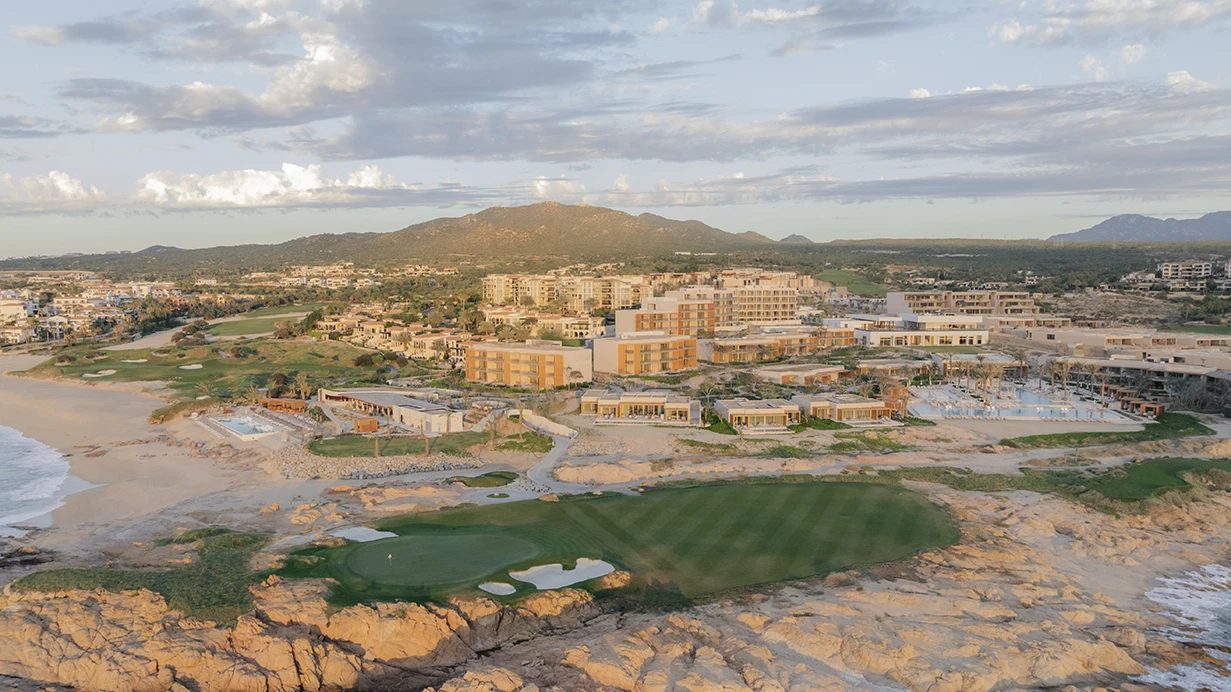
That number matters, but context matters more. A 0.67-meter rise would reshape low-lying coastal areas, but the majority of Los Cabos' developed real estate sits on elevated, rocky terrain. The granite headlands that define the coastline from Cabo San Lucas through the Tourist Corridor are not going underwater anytime soon.
What 0.67 Meters Actually Means for Cabo
In South Florida, a 0.67-meter sea level rise is catastrophic because the entire coastal plain sits 1 to 2 meters above sea level on porous limestone that cannot be effectively seawalled. Water comes up through the ground. In Cabo, the terrain profile is fundamentally different. The coastline is predominantly granite with dramatic elevation changes — you go from sea level to 30 meters within a few hundred feet in many areas.
The communities most exposed to sea level rise in Los Cabos are:
- Low-lying beachfront in East Cape — flat, sandy terrain with minimal elevation buffer
- Parts of the marina district in Cabo San Lucas where reclaimed land sits near sea level
- Select Pacific-side beach communities in Cerritos Beach and El Pescadero where construction is close to the shoreline
The communities with the strongest natural protection include:
- Pedregal — clifftop terrain averaging 30 to 50 meters above sea level
- Quivira — elevated headland position with granite foundations
- The Tourist Corridor — most developments sit on bluffs 10 to 30 meters above the beach
- Inland communities like Rancho Paraiso and Club Campestre that have zero coastal flood exposure
Hurricane Intensity and Building Resilience
Baja California Sur averages a significant hurricane impact roughly every 10 to 15 years. Compare that to Florida's 3 to 5 year cycle or the Caribbean's near-annual threat. The last major event was Hurricane Odile in September 2014 — a Category 3 storm that caused over $1 billion in damage, mostly to older structures and commercial infrastructure.
Baja surface temperatures are projected to rise 2 to 4 degrees Celsius by 2100, according to IPCC modeling. Warmer ocean temperatures fuel stronger hurricanes, meaning that while Cabo may not see more frequent storms, the storms that do arrive could be more intense.
Post-Odile Building Codes
Hurricane Odile was a watershed moment for Cabo construction standards. The Baja California Sur building code was significantly strengthened afterward. Here is what changed:
- Reinforced concrete and CMU construction rated for Category 4 wind loads is now standard for new development
- Impact-resistant glazing or hurricane shutters are required for all units within 500 meters of the coastline
- Underground utility lines are mandatory in new developments, eliminating the downed power line problem that plagued post-Odile recovery
- Backup generator and water storage requirements for multi-unit developments
Walk through any development built after 2016 in Los Cabos and you will see construction quality that rivals or exceeds what is being built in Florida. The difference is that Cabo developers learned from a single catastrophic event and immediately upgraded their standards, while Florida continues to debate building code enforcement decades into their hurricane cycle.
Want to Evaluate a Property's Climate Resilience?
We walk you through elevation data, building construction, and infrastructure resilience for every community in Los Cabos.
Book a CallWater Scarcity: The Bigger Risk No One Talks About
If I am being honest, sea level rise is not the climate risk that keeps me up at night in Cabo. Water is. Los Cabos sits in the Sonoran Desert ecosystem and receives only 150 to 200 millimeters of annual rainfall. The region depends primarily on aquifer extraction, and those aquifers are being drawn down faster than they recharge.
The population of Los Cabos has grown from roughly 68,000 in 2000 to over 350,000 today. Tourism adds another 3 million visitors annually. That demand curve puts enormous pressure on water infrastructure that was designed for a fraction of today's usage.
Desalination as Infrastructure Indicator
The smartest developments in Los Cabos have already moved to address this. Desalination capacity is rapidly becoming a differentiator between developments that are thinking long-term and those that are not.
When I evaluate a new development, one of the first questions I ask is about water sourcing. Developments investing in on-site desalination, wastewater recycling, and gray water irrigation systems are telling you something about their commitment to long-term viability.
Key water infrastructure developments in the region include:
- Municipal desalination plants serving Cabo San Lucas and San Jose del Cabo
- On-site desalination at major resort developments including several along the Tourist Corridor
- Wastewater treatment and recycling for golf course irrigation (reducing aquifer draw by significant volumes per course)
- Mandatory water-efficient landscaping requirements in newer developments that favor native xeriscape over imported tropical plants
How Cabo Compares to Florida, Hawaii, and the Caribbean
Every buyer I work with who is considering Cabo is also looking at other warm-weather destinations. The climate risk comparison is rarely discussed, but it should be.
| Factor | Los Cabos | South Florida | Caribbean |
|---|---|---|---|
| Avg Coastal Elevation | 10 to 50+ meters (varies) | 1 to 2 meters | 1 to 5 meters (most islands) |
| Coastline Type | Rocky granite | Porous limestone/sand | Coral/sand |
| Hurricane Frequency | Major impact every 10 to 15 years | Every 3 to 5 years | Annual threat |
| Insurance Cost (% of value) | 0.3 to 0.5% | 1 to 3% | 1.5 to 4% |
| Sea Level Rise Risk | Low to moderate (elevation-dependent) | Severe | Severe |
| Primary Climate Risk | Water scarcity | Sea level rise + surge | Hurricanes + sea level |
The insurance data alone tells the story. When insurers charge 3 to 6 times more to cover a Florida beachfront property than a comparable Cabo property, they are pricing in a risk differential that buyers should pay attention to.
How Smart Developments Are Adapting
The best developers in Los Cabos are not ignoring climate trends — they are building around them. Here is what adaptation looks like on the ground:
- Solar integration: Multiple developments now include rooftop solar as standard, reducing grid dependence and providing backup power during storm events
- Desalination capacity: On-site desalination plants that make developments water-independent from municipal supply constraints
- Elevated construction: Raised foundations and first-floor living spaces in low-elevation areas, with parking and storage at grade level
- Native landscaping: Shifting from water-intensive tropical gardens to native desert and drought-tolerant plantings that require 60 to 80 percent less irrigation
- Stormwater management: Modern drainage and retention systems designed for the intense but infrequent rainfall events that characterize the Baja climate
Insurance Implications for Cabo Property Owners
Property insurance in Los Cabos typically runs 0.3 to 0.5 percent of insured value annually. For a $500,000 property, that is $1,500 to $2,500 per year. By comparison, insuring a $500,000 beachfront property in a high-risk Florida zone can cost $5,000 to $15,000 annually — and some areas are becoming effectively uninsurable through private markets.
Post-Hurricane Odile, some insurers became more selective about coverage for low-elevation beachfront properties in Baja. But elevated properties in established communities generally see stable or declining rates because the construction quality of post-2016 buildings dramatically reduces claim risk.
When I advise buyers on insurance for Cabo properties, I emphasize three things:
- Get a policy that covers named storms — some budget policies exclude hurricane damage
- Document your property thoroughly with photos and video before hurricane season (June through November)
- Consider an umbrella policy if you plan to rent the property, as short-term rental activity adds liability exposure
The 50-Year Investment View
Climate change is a long-term factor, and real estate is a long-term investment. If you are buying a property in Los Cabos with a 20 to 50 year horizon, the climate resilience profile matters as much as the view.
What I tell every buyer: choose elevation and infrastructure over beachfront proximity. A property at 30 meters elevation with desalination, solar, and modern construction will hold its value through climate disruption far better than a ground-level beachfront unit in a development that depends entirely on municipal water and grid power.
The communities I am most confident in from a long-term climate perspective are the ones investing in infrastructure independence — their own water, their own power, and construction designed for the storms that will come.
For a deeper look at community-by-community comparisons, visit our Pedregal, Quivira, and Costa Palmas guides, or explore our full resource library for buyer research tools.
Invest With Climate Confidence
We will help you identify the communities and developments in Los Cabos that are built for the next 50 years, not just the next 5.
Get StartedFrequently Asked Questions
How much will sea levels rise in Los Cabos by 2100?+
NASA modeling projects approximately 0.67 meters (about 2.2 feet) of sea level rise for the Cabo region by 2100 under intermediate emissions scenarios. Global sea levels have already risen 15 to 18 centimeters over the past century, and the rate has doubled since 1993.
Is Cabo at risk from hurricanes?+
Yes, but less frequently than Caribbean destinations. The Baja peninsula averages a significant hurricane impact every 10 to 15 years, compared to Florida's 3 to 5 year cycle. Hurricane Odile in 2014 was a Category 3 that caused major infrastructure damage, and the region has since invested heavily in building codes and storm-hardened infrastructure.
Does Cabo have a water scarcity problem?+
Los Cabos sits in one of the driest regions in North America, receiving only 150 to 200 millimeters of rainfall annually. The region depends on aquifer extraction and increasingly on desalination. Major resort developments are now required to include on-site desalination or wastewater recycling as a condition of their permits.
Which Cabo communities are most climate resilient?+
Elevated communities like Pedregal (150 feet above sea level), Quivira (clifftop terrain), and Rancho San Lucas offer the most natural protection from sea level rise and storm surge. Low-lying beachfront communities in East Cape and along the Pacific Side face more exposure but benefit from less development density.
How does Cabo compare to Florida for climate risk?+
Cabo's rocky, elevated coastline provides a significant natural advantage. South Florida averages only 4 to 6 feet above sea level with porous limestone that cannot be effectively seawalled. The Baja coastline is predominantly granite with significant elevation changes, making it less vulnerable to both sea level rise and storm surge.
Are insurance costs rising for Cabo properties?+
Property insurance in Los Cabos typically costs 0.3 to 0.5 percent of insured value annually, compared to 1 to 3 percent in hurricane-prone Florida zones. Post-Hurricane Odile, insurers have become more selective about low-elevation beachfront coverage, but elevated properties generally face stable or declining rates.
Do Cabo developers build for climate resilience?+
Yes, increasingly so. Post-2014 building codes in Baja California Sur require hurricane-resistant construction. Major developments now incorporate on-site desalination, solar arrays, elevated foundations in flood-prone areas, and reinforced concrete construction rated for Category 4 winds.

Aaron Cuha
Real Estate Advisor & Los Cabos Market Expert
Real estate advisor and founder of Living In Cabo. 15+ years helping families navigate complex real estate decisions. Strategic partner with Ronival — Baja's largest brokerage.